bloc_article_content

French cartography of the Saint Lawrence River

Access to documents

The oldest known maps of the Saint Lawrence River are the work of Norman cartographers who collected information from sailors who had navigated the Atlantic Ocean.

Produced in the 1540s and 1550s, Norman maps took the form of large planispheres depicting the world as it was then known to Europeans. A separate North-American continent is shown, distinct from Asia, as is the Saint Lawrence River, its banks dotted with French and Indigenous place names. Iconographic depictions of North American flora and fauna, as well as dubious drawings of Indigenous peoples, appear side by side with illustrations of ancient and medieval legends, like the unicorns and Pygmies on a map by Pierre Desceliers. Few texts and mpas a this time agreed on geography but several toponyms (place names) on Norman maps reflects the official voyages made by Jacques Cartier and Jean-François de la Rocque de Roberval between 1534 and 1543. Sailors generally oriented themselves with a compass and recorded observations, like travel distance between places, in charts and ships' logs. This information could then be transformed into basic maps of the places the ship had visited, in the tradition of the portolan charts that had already been used for the Mediterranean Sea since the 14th century.

Norman cartography harnessed nautical knowledge to map accurate coastlines, but barely touched on the geography of inland territories, sailors being largely unwilling to leave their ships for unexplored lands. While Norman maps suggest they knew almost nothing of Indigenous territories in the interior, what little toponymy there is bears traces of contact with Iroquoian villages on the Saint Lawrence River. The name “Quebecq,” an Algonquian toponym, first appears on a map from Dieppe dated 1601. This adoption of Indigenous language is just one of many signs pointing to regular contact between European traders and local inhabitants.

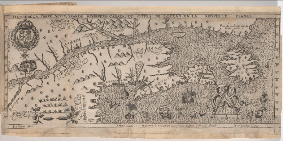
In the early 17th century, maps of the Saint Lawrence River were published by two major figures in the French colonization of the Americas, Marc Lescarbot and Samuel de Champlain. Their maps locate the settlements of the French in Acadia and Canada. Compared to his predecessors, Champlain was particularly innovative in his description of the territories claimed by France. His personal inspection of the land recorded not only the distances and directions he traveled, but also information from Indigenous guides about places and peoples beyond his route. On returning to France after his expedition to Canada (1603), he hastened to publish an account of his journey, titled Des Sauvages, and to report to King Henri IV, to whom he showed a map of the lands he had visited. The map was never published, but we can surmise that a later map of New France, dated 1612, contains the information gathered from Indigenous informants nine years earlier. For example, the later map shows not only the stretch of the Saint Lawrence River known to the French (from the Atlantic Ocean to Montreal), but also the river’s western course, not yet visited by Champlain, with a winding stream leading to two successive Great Lakes separated by a large waterfall (Niagara Falls).

In the second half of the 17th century, Louis XIV and his government turned their attention to the navigability and cartography of the Saint Lawrence, the primary route between France and Canada. Their main concerns were navigational hazards like reefs, rocks, shoals, currents, fog, and storms, which had already capsized an alarming number of French ships. Unsurprisingly, several colonial administrators and navigators had made complaints about the lack of accurate maps. In response, experts from both France and New France were solicited to produce a more practical nautical cartography. A merchant born in the colony, Louis Jolliet, offered to share the knowledge he had acquired on his many trips between Quebec City and his lands at the mouth of the Saint Lawrence (Mingan and Anticosti Island). With the help of the draughtsman Jean Baptiste Louis Franquelin, he produced the Carte du grand fleuve St Laurens in 1685, showing the safest sailing route, best moorings, and largest obstacles on the river. 
 
At the same time, the King sent Jean Deshayes, a mathematician-astronomer close to the Académie Royale des Sciences, to New France to conduct scientific surveys. Used to such journeys (having already visited Africa and the Antilles), Deshayes went to the colony with technical knowledge and skills that allowed him to produce a detailed cartography. His work was distinguished by triangulation and systematic soundings, accurate enough that were still in use almost 70 years later.
 
Interest in mapping the river surged in the 1730s after the shipwrecks of the Chameau (1725) and the Éléphant (1729), leading to another mapping project that involved both France and New France. An unparalleled network of observation and information-gathering was set up, coordinated from Paris and stretching all the way to Quebec and Rochefort. Some participants were designated to sail across the Atlantic, while others remained where they were and cultivated local knowledge, safe from the dangers of transatlantic travel. As per their instructions, naval officers recorded their observations in ships’ logbooks and on field maps that were brought back to France. The Marquis de l’Estanduère, not content with answering only the prescribed questions, produced his own cartography of the places he visited during two campaigns, in 1730 and 1732. His maps then served as a base model, copied and enriched in the colony by local navigators and in France at the Dépôt des cartes et plans de la Marine.
 
The widespread availability of accurate maps of the Saint Lawrence River also had its dangers, particularly the risk that France’s enemies would acquire this precious geographical knowledge. The difficulties of navigating the river were an essential part of French colonial defenses, as the spectacular wreck of the British Admiral Walker and his fleet on their way to Quebec (1711) shows. It followed that new data from the region was issued only in restricted form: no detailed maps of the Saint Lawrence would be published before the loss of Canada in 1763.


Published in may 2021

Réduire l'article ^

Liste des documents

Read more >
SEE THE COLLECTIONS ON GALLICA >
  • escription du fleuve de...
  • Plan de la rivière depuis...
  • Partie du grand fleuve de...
  • Carte générale des...
  • Carte française du Saint...
  • Carte du lac Ontario et du...
  • Carte du cours du fleuve...
  • Carte de la rivière de...
  • Cours du Saint - Laurent...
  • Figure de la Terre Neuve,...
  • An authentic plan of the...
  • L'entrée de la Rivière du...
  • Carte de la rivière de...
  • La Grande Rivière de Canada...
  • Carte marine de l...
  • Veües de Charité. 1687
  • Plan de la traverse qui est...
  • Demonstration d'une Partye...
  • Carte particulière du...
  • Basse partie et orientale...
  • Carte depuis Kébec jusque...
  • Suite du cours du fleuve St...
  • Partie du fleuve St Laurent...
  • Partie du fleuve St Laurent...
  • Partie du fleuve de Saint...
  • L'Isle Royale située à l...
  • Le fleuve Saint-Laurent...
  • Carte du golfe et du fleuve...
  • Carte du cours du fleuve St...
 
 
Afficher tous les documents >