bloc_article_content

From the St. Lawrence Valley to the Great Plains (17th-18th C.)

Access to documents

Voyages of exploration and their attendant colonial objectives resumed under Henri IV, whose reign (1589-1610) marked the return of civil and religious peace.

In the early 17th century, Pierre Du Gua de Monts (1558-1628), the principal beneficiary of French commercial monopoly between 1603 and 1609, and Samuel de Champlain (ca. 1580-1635), an observer and then an expedition leader, were the driving forces behing the exploration of Canada, from the coast of Acadia (Nova Scotia) to the Great Lakes. In 1603 an expedition seeking trade and new discoveries traveled up the Saint. Lawrence River to Hochelaga (Montreal). From 1604 to 1607, Du Gua de Monts systematically explored the coasts of Acadia and New England, all way to Cape Cod, in search of a promising site for colonial settlement. After founding Quebec in 1608, Champlain traveled north on the Saguenay River, south on the Richelieu River (1609), and west on the Ottawa River as far as Lake Huron (1613, 1615-16).

Expeditions in the following decades concentrated on the Great Lakes region and, unlike earlier explorations, were rarely government sponsored. The principal actors were missionaries who hoped to evangelize Indigenous peoples. After the destruction of the Wendat confederacy and its trade networks (c.1650), coureurs de bois (illegal traders) began to venture into the Pays d’en Haut (Great Lakes region) in search of the furs necessary to the survival of New France. It was only after 1663 that colonial authorities resumed planning and directing expeditions and collecting the resulting reports, journals, and maps.

Despite the reticence of Louis XIV (r. 1643-1715) and Jean-Baptiste Colbert, his First Minister of State, the colony's Intendant Jean Talon (and later Governor Frontenac) encouraged exploration, urging their agents to claim the lands they encountered in the name of the king. To the traditional objectives of developing trade posts, searching for mineral deposits, and finding a route to Asia, a new consideration was added: the need to block British expansion and influence in the continental interior. This rivalry explains the Franco-British conflict over Hudson Bay, whose premium fur trading post had been bankrolled by an English company at the initiative of two French coureurs de bois, Médard Chouart des Groseilliers (1618-1696) and Pierre-Esprit Radisson (c.1636-c.1710).

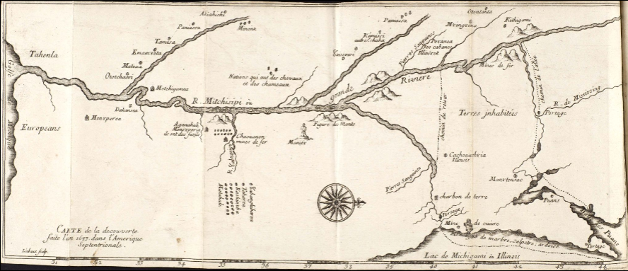
Governor Frontenac charged cartographer Louis Jolliet (1645-1700) with the task of finding the mouth of the great river that Indigenous peoples called Michissipi. Accompanied by the Jesuit Jacques Marquette (1637-1675), he reached the confluence of the Arkansas River in 1673, then retraced his steps to double-check his most important finding: the Mississippi flowed southward, not toward a hypothetical “Western Sea.” The expedition organized by René-Robert Cavelier de La Salle (1643-1687) reached the river’s delta by land in 1682, where La Salle solemnly claimed possession of the lands he christened “Louisiana” in honor of Louis XIV. Despite a second commission conferred on La Salle in 1684, Europeans did not reach the mouth of the river until Le Moyne d’Iberville located it by sea in 1699.
 
In the 18th century, Louisiana served as a point of departure for numerous expeditions considered indispensable to the security and development of the colony: building alliances with First Nations on the Mississippi and its tributaries, seeking out new natural resources for trade with France, and developing commercial relations with the Spanish colonies – with, as always, the underlying hope of discovering a passage to the fabled Western Sea. Louis Juchereau de Saint-Denis (d.1744) ascended the Red River to Natchitoches in 1714; Bénard de la Harpe (1683-1765), an adventurer from Saint-Malo, traveled the upper valleys of the Red and the Arkansas Rivers in 1719; and Etienne Veniard de Bourgmont (b.1679) explored the Missouri River as far as its confluence with the Nebraska in 1723-24. In 1739, two Canadian traders, the brothers Pierre-Antoine and Paul Mallet, left Fort Chartres in the Illinois Country, traversing the Great Plains all the way to Santa Fe. Finally, a family of French-Canadian explorers, the La Vérendryes, continued the search for the Western Sea in the years 1730-40, crisscrossing the region of Lakes Winnipeg and Manitoba and the upper Missouri River.


Published in may 2021

Réduire l'article ^

Liste des documents

Read more >
SEE THE COLLECTIONS ON GALLICA >
  • Mémoire des observations...
  • Lettre ou mémoire du...
  • Carte de la coste de la...
  • Carte nouvelle de la partie...
  • Remarks and observations...
  • 4 Mar 1700. Fort...
  • Relation des avantures de...
  • Extrait du plan de la ville...
  • Carte du Lac Ontario et de...
  • Carte du cours du...
  • Embouchure du fleuve St...
  • Carte du cours de la...
  • Isle Royale 18e
  • Carte du Canada et de la...
  • Embouchure du Mississipi M...
  • Carte des Nouvelles...
  • Carte des Nouvelles...
 
 
Afficher tous les documents >
Read more >
SEE THE COLLECTIONS ON GALLICA >
  • Nouvelles de l'Amerique, ou...
  • Carte de l'Amérique...
  • Memoir H. de Tonti. 1689
  • Discovery and exploration...
  • Account of La Salle's...
  • Travels in Canada Baron de...
  • History of Brulé's...
  • Relation dernière de ce qui...
  • Carte de l'Océan Atlantique...
  • Voyage fait par ordre du...
  • Plan du port de Chibouctou...
  • Nouveaux voyages aux Indes...
  • Demonstration d'une Partye...
  • Voyage de la Louisiane,...
  • Journal du voyage de la...
  • Carte de la decouverte...
  • Découverte du cours du...
  • Carte française du Saint...
  • Nouvelle France, Nouvelle...
  • Adieu à la France sur l...
  • Histoire de la Louisiane,...
  • Voyage d'Iberville. Journal...
  • Au Mississipi, la première...
  • Carte manuscrite du pays...
  • Histoire et description...
  • Journal historique de l...
  • L'expédition de Cavelier de...
  • Nouveaux voyages de M. le...
  • Historiae Canadensis seu...
  • Carte du Mexique et de la...
  • Jacques Marquette (1637-1675)
  • Louis Jolliet (1645-1700)
  • Louis Hennepin (1626-1705)
  • Samuel de Champlain (1567?...
  • Jacques-Nicolas Bellin ...
  • Jean-Baptiste Bourguignon d...
  • Carte de l'Océan Atlantique...
  • Nouveaux voyages dans l...
 
 
Afficher tous les documents >