Maps of Bengal
From the collection of Service hydrographique de la Marine dedicated to Bengal and the surrounding areas including Ganges Delta.
Special map of the mouth of the Ganges and other rivers in the Kingdom of Bengal, 1714

-
[Côte orientale du golfe du Bengale, de Chittagong au cap Negrais]. 16..-17..
-
Carte de la côte orientale du golfe de Bengale. 16..-17..
-
Carte de la côte de Châtiganz à l'est du golphe de Bengale. 16..-17..
-
Plan de la rivière de Chatigan et d'une partie de la communication avec Daca. Charles-Pierre Claret de. Fleurieu. 1786
-
Carte plate du golfe de Bengal depuis la ligne équinoctiale jusqu'à l'embouchure du Gange. 17...
-
Sinus Gangeticus ; vulgo Golfo de Bengala. Nova descriptio. 16..-17..
-
Carte particulière de la baye de Bengala, avec les sondes. 16..-17..
-
Carte du golphe de Bengale : tiré de la Carte de l'Ocean Oriental. Jean-Frédéric Phélypeaux. Maurepas. 1740
-
A mapp of the Greate river Ganges : as it emptieth it selfe into the bay of Bengala. Samuel. Thornton. 17...
-
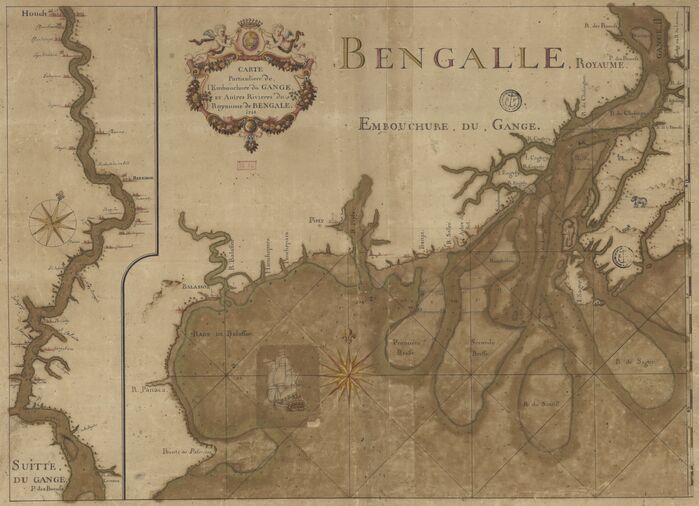
Carte particulière de l'embouchure du Gange et autres rivières du royaume de Bengale. 1714
-
Plan du Gange depuis la pointe des Palmiers jusqu'à Ougly. 1748
-
Instructions pour l'entrée du Gange. Faucher. 1696
-
Carte du Gange depuis le cap des Palmiers jusqu'au Bandel. 17...
-
A new & correct chart shewing the goeing over the braces wiyh the sand shoals depth of water and anchorage from Point Palmiras to Hughley in the Bay of Bengal. 17...
-
Plan d'une partie de la rivière d'Ougly sur le bord occidental du Gange. Hugh. Cameron. 1764
-
Carte de la coste de Cormandel, Orixa et Gergelin. 1688
-
Carte de la coste de Coromandel ou est aussy comprize celle d'Orixa et de Gergelin. 1688
-
[Carte de la côte orientale de l'Inde copiée d'après une carte hollandaise]. 16..-17..
-
[Côte orientale de l'Inde depuis Ceylan jusqu'à la pointe des Palmiers]. 16..-17..
-
[Carte hollandaise des côtes de Coromandel et Orissa]. 16..-17..
-
Théâtre de la guerre dans l'Inde sur la coste de Coromandel / par M.B.C.T. [M. Bourcet ?]. Jean-Baptiste. Croisey. 1770
-
[Carte hollandaise des côtes de Coromandel et Orissa]. 16..-17..
-
Carte de la rivière du Gange : depuis son embouchure jusqu'à Chinchura. 1714
-
Plan du fleuve du Gange situé au roy[au]me de Bengal, aux Indes orientales. 16..-17..
-
Plan du fort Williams de calcuta, au Bengale. Louis-Marie-Joseph Ohier. Grandpré. 1790
-
Plan de la forteresse située à 300 toises de Golcota. 17...
-
Het opkomen en vervolg van de Rievier de Ganges of Hugley : strekkende van P. Palmiras en't Eÿland Sagor tot op de hoogte van Chandernagor en Bandel. Johannes II. Van Keulen. 17..
-
A plan of the docks, slips, and dock yard, constructing at Calcutta. Henry Watson. 1777