Maps of Mahe
From the collection of Service hydrographique de la Marine dedicated to the port of Mahe and the surrounding areas
Plan of the trading post of Mahé and its surroundings, 1778

-
Coste de Malabar. 16..
-
Carte de la côte de Malabar [entre Onor et le cap Comorin]. 17..
-
Cours de la riviere de Mahé. 1727
-
Carte de Mahé. Louis. Paradis de la Roche. 1738
-
Carte générale du cours de la rivière de Maÿé. Lambert. 1729
-
Carte plate qui comprend l'Isle de Ceylan et une partie des côtes de Malabar et de Coromandel. G. Dheulland. 17..
-
Plan de la riviere de Mayé stué dans le royaume du Prence Barguaray, coste Malabar, lat[itu]de N. 11 deg[rés] 35 m[inutes]. 17...
-
Carte de Maye a la coste de malabar avec tous ses environs. 17..
-
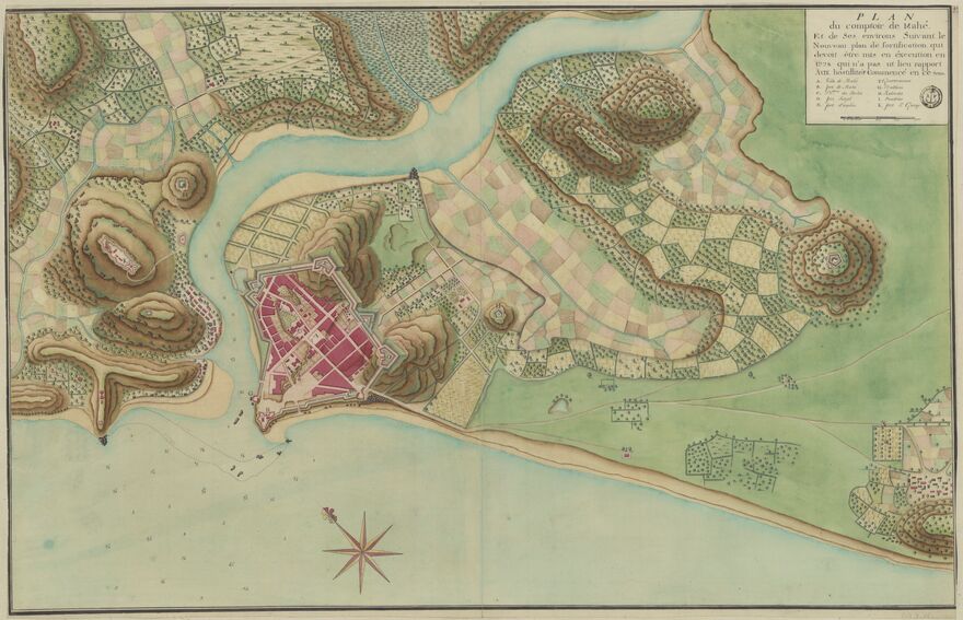
Plan du comptoir de Mahé et de ses environs suivant la nouveau plan de fortification qui devoit être mis en éxecution. 1778-1790
-
Plan de Mayé, coste Malabare par les XI d. XL m. [11°60'] de latitude nord. 1730-1760
-
[Carte de Mahé et ses environs]. B. Fermet. 1730
-
[Mahé et ses environs]. B. Fermet. 1730
-
[Carte de Mahé et ses environs]. 1739-1750
-
Mahé 1740, fort de Condé commencé le 7 janvier sur la montagne de Corragouroup. Louis. Paradis de la Roche. 1740
-
[Mahé et ses environs]. Reynaud. 1741
-
Mahyé Xbre 1742, fort sur la montagne verte. Reynaud. 1742
-
Plan du fort Dauphin, Mahyé. Reynaud. 1742
-
Plan de la coste de Mallabar, des Lacardives et d'une partie des Maldives. 1743
-
De kust van Malabaar [en de] kust van Decan. Jan Van. Jagen. 1756
-
[Les îles Lacardives et la côte de Malabar]. François-Pierre. Le Moyne. 1764
-
Carte des côtes de Guzerat, de Concan et de Canarasur les observations de F-E. Rosili ; Besançon ; J-B. Croisey. 1798-1799
-
Carte de la partie méridionale de la presqu'isle de l'Inde qui comprend l'isle de Ceylan. F-E. Rosili ; J-B. Croisey. 1798-1799